Academician Yakiv Didukh recently returned from an expedition to the shores of the Kakhovka Reservoir. In the article originally published in the newspaper “Svit” he outlined his observations, impressions, and forecasts.
The destruction of the Kakhovka HPP is a large-scale environmental disaster that caused the greatest environmental damage to the environment, which we interpret as ecocide. The result and consequences of the destruction of the Kakhovka HPP meet both each of the individual items and the concept of ecocide as defined in Article 141 of the Criminal Code of Ukraine.
Should Kakhovka HPP be restored?
Kakhovka HPP and the reservoir performed various functions: electricity supply, shipping, irrigation and water supply – drinking and technical: industry, energy (in particular, cooling of Zaporizhzhia NPP reactors). But this territory (without the hydroelectric power plant and reservoir) can also provide ecosystem services, which also have their own price and value.
Each of the above functions should be economically evaluated. And only then should we decide whether to rebuild this hydropower plant or not.
Electricity vs. ecosystem services
The total capacity of Ukraine’s hydropower plants is 4,600 MW, and they produce only 8% of electricity. The capacity of the Kakhovka HPP was 351 MW, so its share in the system was only 0.9%. At the same time, the area of the Kakhovka reservoir was 2,150 km2, or 23% of the area of reservoirs in Ukraine and 31.2% of the area of reservoirs in the Dnipro Cascade. Therefore, even an ordinary person may wonder whether it was reasonable to flood so much territory to generate 1% of electricity.
Let’s multiply the amount of electricity the HPP produced annually, and the current electricity cost for enterprises 5 UAH/kWh. The cost of electricity produced by Kakhovka HPP can then be estimated at UAH 15,37 billion. Now let’s assess the Dnipro floodplain that is not flooded by the Kakhovka Reservoir (70% of its area), in particular – the ecosystem services of potential quasi-stable (conditionally stable) natural ecosystems of the floodplain. Such ecosystem services as biomass accumulation (increasing energy reserves, carbon sequestration); regulation of surface runoff and outflow of substances; flood and erosion control; climate regulation and air quality improvement; recreation and health improvement, etc. are estimated by different methods to be worth from 3,7 to 17 million UAH/ha/year. That is, an average of UAH 10 million per hectare per year. This means that this hydropower plant produced electricity worth only 8,9% of the value of ecosystem services per year.
Although these calculations are approximate, not accurate, and perhaps not entirely correct, since they do not take into account the ecosystem services of the reservoir itself, they clearly indicate a low relative contribution of electricity generated. At the same time, the calculation did not take into account aspects related to the possibility of using the land freed from the reservoir for agriculture or other activities, the historical value of the territory that has emerged from under the water, etc. The scales will be tipped against the restoration of hydroelectric power plants also because, unlike in the early twentieth century, there are other alternative available to generate electricity.
Three other functions remain important. The reduction of the water level from 16 meters to the current level and the remaining water resources in the natural riverbed will probably not provide the necessary volume for navigation, irrigation and cooling of nuclear reactors. There are two ways to solve these problems. The first is to deepen and technically reconstruct the riverbed. However, it is technically difficult to do this from both the riverbed and the floodplain banks: the wide floodplain is covered with wet, viscous silt. The second option is to raise the water level to a certain volume, which will be significantly lower than before the dam was destroyed.
Wetland, steppe, forest
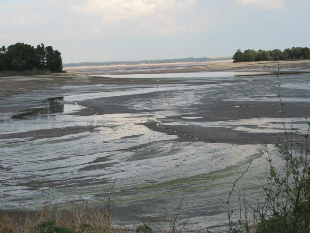
In this case, large areas of the floodplain will either remain unflooded or become shallow. The Dnipro floodplain here is undulating, bisected by numerous streams, groundwater and surface water outlets, and will be overgrown by different types of vegetation, depending on moisture and substrate structure. Theoretically, five types of biotopes can form: aquatic, beaches and dunes, coastal marsh, meadow-steppe, and shrubland-forest.
Aquatic habitats include oxbow lakes, old waterways and tributaries of the Dnipro. As they stabilize and drain, their area will decrease, and eutrophication (an increase in the amount of organic matter) and siltation are possible. They are important as regulators of water flow, places where certain species of fish, birds and animals live, and rare plants grow.
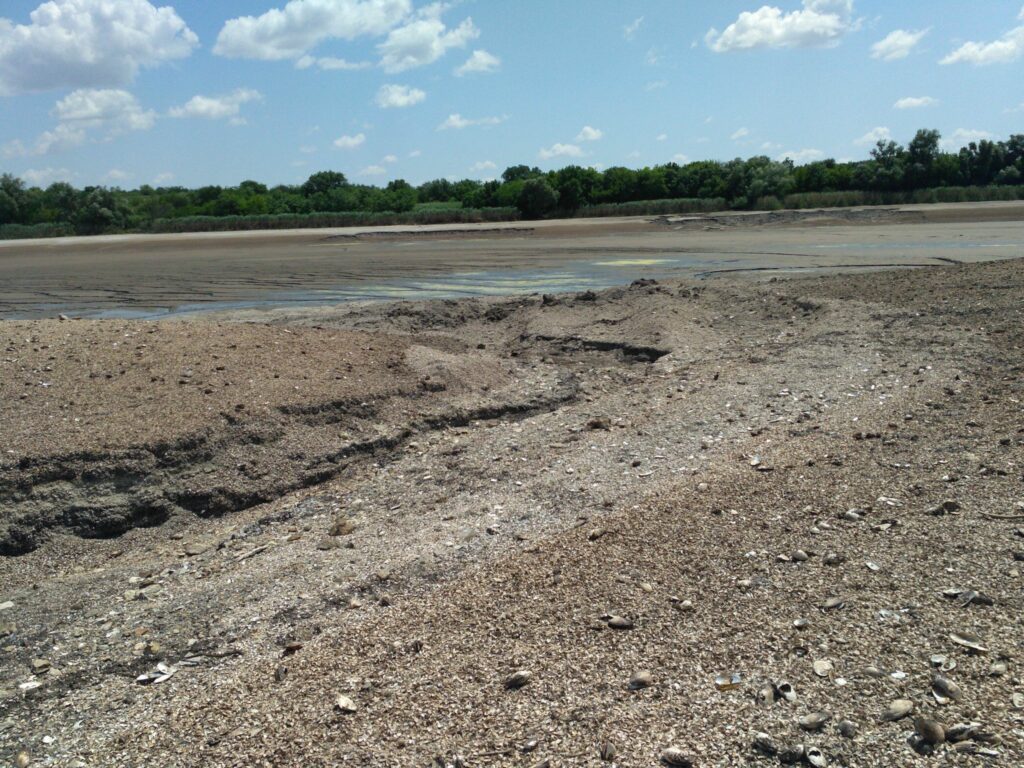
Beaches and dunes, composed of sand, mud and shell sediments, although have high aesthetic value, but are characterized by low amount of other ecosystem services. They are dangerous as a source of dust storms, erosion processes, etc., but their area will shrink, and they will be locally distributed.
Coastal wetland communities play an important role in soil formation (accumulation and protection of soils and coastal area, erosion reduction, attenuation of surge waves, accumulation of carbon compounds, etc.), but they will not occupy large areas and will be formed mainly along watercourses and in waterlogged depressions.
The most interesting in this list are the meadow-steppe habitats that were characteristic of the Dnipro floodplain (Velykyi Luh), but they cannot be restored for several reasons. Meadows are derivative communities characterized by the dominance of grasses, and to form grasslands, their stems must be cut, which means grazing or haymaking, which requires significant costs (for livestock, machinery, production and material base, etc.). In this case, it will not be possible to organize this also because large areas of mudflats are waterlogged, and animals will not be able to move. In the process of floodplain drying, it is theoretically possible to locally form meadow and even steppe areas on dry sandy deposits or riverbank slopes.
The largest area of the restored Dnipro floodplain is likely to be occupied by shrub and forest communities. And this is most appropriate. Firstly, they regenerate quickly, are characterized by vigorous growth and will cover open areas. They are of great importance. They accumulate biomass and store carbon (important for reducing climate change and increasing forest cover). They regulate surface runoff and cycle of chemical elements and compounds, counteract floods, erosion processes, improve air quality, etc.
The scale, dynamics of formation of different habitat types, and value of ecosystem services are different, but the end result, the assessment of significance, is that the Dnipro floodplain should contain as much diversity of habitats as possible. Today, we should not be talking about restoring what happened 70 years ago, because the basis for restoration has been lost, but about forming quasi-stable ecosystems of various types.
“Takyr” soils are being formed
As the area is under the direct influence of ongoing military activities or is affected by their indirect impact, it is inaccessible for either scientific research or technical measures. But nature will not wait, and the processes are already underway.
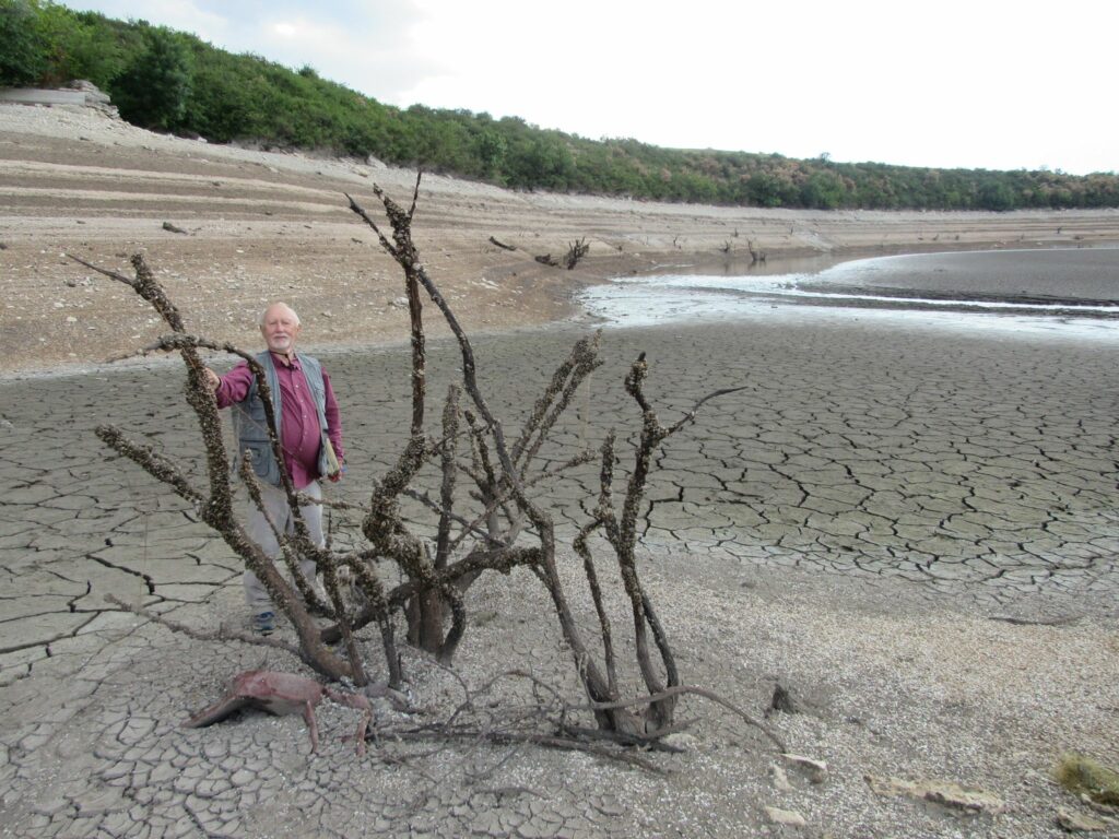
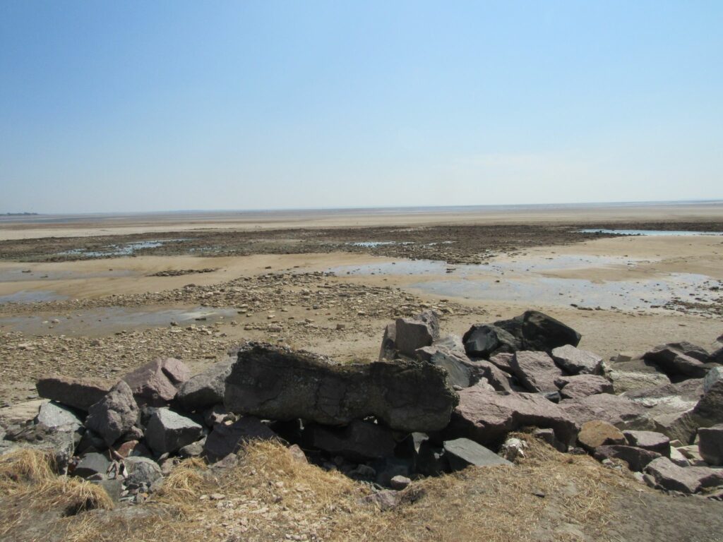
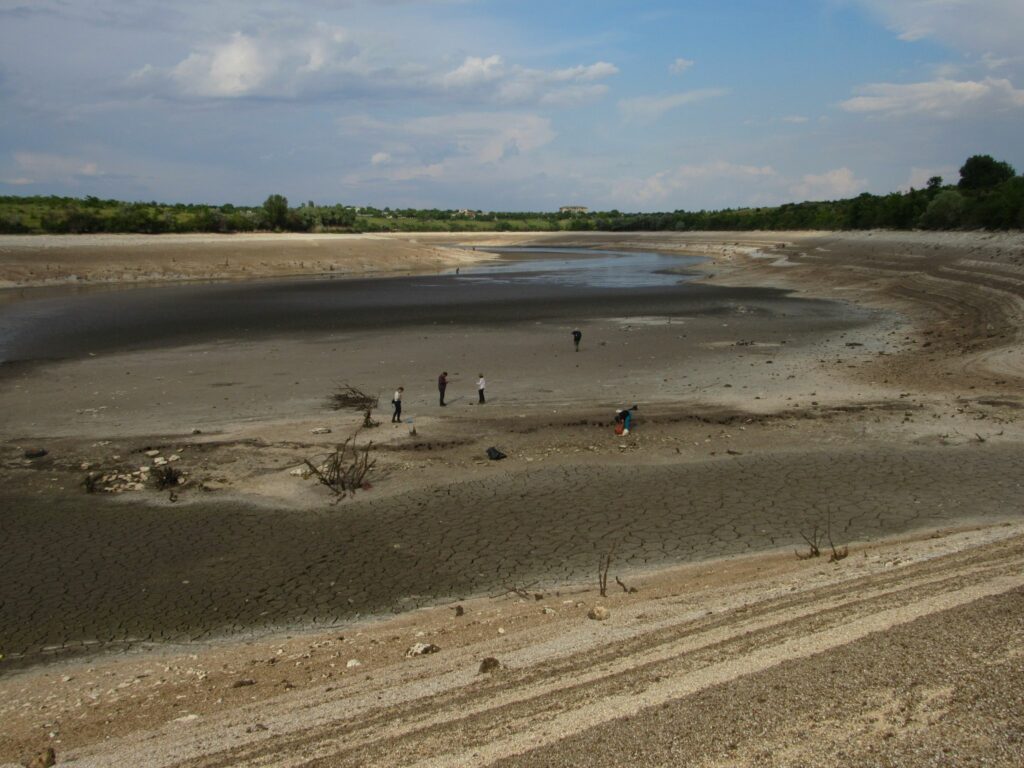
We have examined and briefly investigated only the territory of the right bank of the former Kakhovka Reservoir, so we do not consider the situation of flooding the area below the dam. We saw that after drainage, slabs separated by cracks form over huge areas. Such soils – the so-called “takyrs” – are typical for semi-desert and desert zones, but it is not a type of soil, but a process of “takyrization”, which can be interpreted as desertification. It appears fragmentarily everywhere in flat hollows, where shallow lakes appear after seasonal rains; the drying of a thin water layer exposes a viscous muddy bottom, the surface layer of which decreases in volume, forming a crust broken by cracks into separate polygonal plates of various shapes and sizes that change according to physical processes. The dense surface crust resists processes of wind erosion.
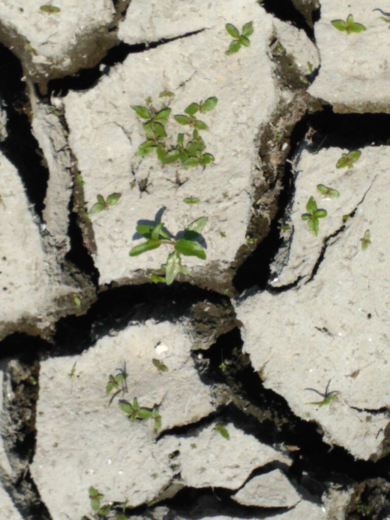
The depth of the cracks reaches an average of 25 cm. The area of the slabs depends on the composition of the bottom sediments, the degree of salinity, drying regime, etc. Typical takyrs are formed when the level of ground waters is at the depth of more than 1.5 meters; in such conditions, salts flow into the groundwater and return through capillaries.
In a dry state, takyr soils are characterized by high strength, and in the dry period, they can even be used for vehicular traffic. But wet takyr soils become highly plastic, viscous, and impassable.
A month after the dam’s destruction, plant sprouts already appeared. On the shell sediments, there are annual purslane and tackweed, whose horizontal shoots cover the soil surface and counteract weathering and erosion processes. The sandy sediments are dominated by barnyard grass, with occasional occurrences of redshank, common amaranth, common beggar-ticks, cocklebur, ragweed, and goosefoot. Some of these species also spread to muddy substrates, where a takyr structure is formed. We also record seedlings of trees and shrubs on the takyrs: various willows, ash-leaved maple. And right next to the dense thickets on the banks, we find green ash (its seedlings), false acacia, thorny honey locust, etc. The false indigo-bush is very common on the “old” banks of the reservoir. It will form the shrub layer.
There will be no desert, but…
But over time, as the vegetation develops, the process of takyrization will fade away and the structure will acquire the typical features of alluvial soils of floodplains. That is why, the headlines “the bottom of the reservoir is turning into a desert” that appear in the media are incorrect and short-sighted.
Depending on the type of substrate, we recorded three initial (pioneer) stages of vegetation development. The list above shows that the vast majority of species are adventive (alien), very resilient and capable of active spread (invasive). Can our willow compete with them? Willow seedlings need constant moisture, but if the root system does not reach the required depth due to drying out of the takyrs, these sprouts may die.
Thus, communities dominated by ash-leaved maple, false acacia, false indigo-bush, etc. may form here. The next stage of formation of quasi-natural communities is floodplain willow forests and gallery-type black poplar forests. Although the value and timber reserves here are much lower than in natural zonal forests, the fact that they provide the above-mentioned ecosystem services is undeniable, so their formation and maintenance is advisable. Theoretically, it is possible to create so-called floodplain oak forests (for example, the “Labyrinth” tract near the village of Trykraty, Mykolaiv region), where Ukrainian landowner and forester Viktor Skarzhynskyi in 1819 established and formed an array of nemoral (broadleaf) forest in the steppe zone.
In drier conditions, it is possible to form shrubby communities of dogwoods, hawthorn, dog rose, common privet, mahaleb cherry, smoketree with the participation of adventive species of false indigo-bush and green ash.
In the strip adjacent to the bare bottom, areas of dense cover of sedges and rushesare recorded. Unfortunately, they do not produce enough seeds either for natural regeneration or for creating a seed base for artificial restoration.
Although the best option is the natural process of ecosystem development, we can and should regulate and influence it to obtain the best possible end result. We are talking about reseeding or replanting natural native plant species that could compete with aggressive invasive species in these conditions, and forming the types of ecosystems that are valuable and provide various ecosystem services. To do this, it is necessary to ensure scientific research, select key test sites, and organize long-term monitoring, which will allow for the development and implementation of measures to minimize negative effects.
Waterfowl farming, aquaculture, and the creation of willow plantations for biofuel are promising in this area. The introduction of certain plant species for agricultural development should also be studied.
Today, the Cabinet of Ministers has already adopted a resolution on the need to restore the Kakhovka HPP. But, in my opinion, we should not start with this, but with the development and evaluation of scenarios, of which there may be four: complete rebuilding of the hydroelectric power plant, partial raising of the reservoir level, preservation of the natural riverbed, and deepening of the Dnipro riverbed. It is necessary to comprehensively, thoroughly argue and calculate (based on the assessment of ecosystem services) the positive and negative consequences, choose the optimal scenario, and only then, based on critical analysis and detailed study, decide on the choice of project. We need to look for the best options, discuss different scenarios for solving this extremely complex environmental and economic problem to minimize the negative consequences of the destruction of the Kakhovka HPP.
by Yakiv Didukh, Academician of the National Academy of Sciences of Ukraine, Doctor of Biological Sciences, professor, Head of the Department of Geobotany and Ecology of the M.H. Kholodny Institute of Botany of the NAS of Ukraine